 |
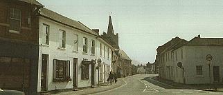
Chobham High Street - on a quiet day! |
 The 19th century saw rapid development of the railways, however the main
lines either routed north to Sunningdale or south to Woking. A light railway was planned at
Chobham, a booking office was actually built, and the road leading east to Mimbridge and
Woking was (and still is) named Station Road. The railway never arrived and the booking
office that never was is now the Castle Grove public house. As a result of connection to
other parts of the country Woking (originally a smaller development than Chobham) grew rapidly while
Chobham's' "isolated" location held back expansion to the point that today, the
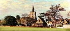
village is only medium-size with a population of about 5000. Many buildings are old and Chobham
centre is a conservation centre where development is severely restricted. Although some
buildings have altered over the years (a few substantially) a fair number remain as they
were built. The more common Georgian architecture to be found is reflected in
traditionally-styled buildings of more recent times. Indeed, the history of the area lives
on in local road names and many fine surviving 16th century farmhouses are to be stumbled
across for the curious to discover along local lanes.
The 19th century saw rapid development of the railways, however the main
lines either routed north to Sunningdale or south to Woking. A light railway was planned at
Chobham, a booking office was actually built, and the road leading east to Mimbridge and
Woking was (and still is) named Station Road. The railway never arrived and the booking
office that never was is now the Castle Grove public house. As a result of connection to
other parts of the country Woking (originally a smaller development than Chobham) grew rapidly while
Chobham's' "isolated" location held back expansion to the point that today, the
village is only medium-size with a population of about 5000. Many buildings are old and Chobham
centre is a conservation centre where development is severely restricted. Although some
buildings have altered over the years (a few substantially) a fair number remain as they
were built. The more common Georgian architecture to be found is reflected in
traditionally-styled buildings of more recent times. Indeed, the history of the area lives
on in local road names and many fine surviving 16th century farmhouses are to be stumbled
across for the curious to discover along local lanes.
Today, local shops have given way to
restaurants and antique shops, the price
being the loss of stalwarts like the butchers and bakers, their trade in turn lost to
supermarkets in neighbouring towns. The High Street boasts enough picturesque buildings to
attract many people looking for Olde Worlde Charm. These same visitors are in their way
now necessary to the economy and well-being of the village. There is much to enjoy and it
has become known as an equestrian centre, riders and walkers alike roam Chobham and
Horsell Commons using the many trackways, footpaths and bridleways. Two small rivers, the
Bourne and the Mill Bourne still flow through the village to meet a mile to the east and are
flanked by pleasant wide water meadows. In 1993 Chobham made the national headlines when
these rivers flooded the village centre, a reflection of the subtle shift in the climate
seen in recent times. For more info on an aspect of the
West End area, click a link below.
|