 |
| The
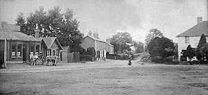
"Hare And Hounds": much-expanded on the original |
 Beyond
the inn (just left of centre) are the shops. "Gordon's View" and the
two "Jubilee Cottages" were all built in 1887 by Mrs. Elizabeth Lucock of
Bagshot. Of the first two shops, one was a drapery & hardware shop and the other
Harts' butcher's. (Their original shop in West End had been opposite Brook Place on the
Chobham road. The building is still there.) The third was a branch of Benham's of
Chobham, selling grocery, corn and meal. Today the shops have been converted into
residential property, although there is a Barbers shop and Martins' Garage just beyond.
Back to the photo, and behind the wooden fence was a well that served all the houses and
cottages on both sides of the road. The ground on which the shops and cottages were built
had once been known as "Turner's Plat" (Turner being a local name), which is
certainly not rhyming slang in honour of one of our famous
players. On the right can be seen Pelling House, the village grocery shop once run by Mrs.
Mary Pelling. Noted for having its own cellar, the building also served time as the post
office, as run by Miss Edith Hone. Of considerable age at the time of the photograph it
was demolished some way into the last century.
Beyond
the inn (just left of centre) are the shops. "Gordon's View" and the
two "Jubilee Cottages" were all built in 1887 by Mrs. Elizabeth Lucock of
Bagshot. Of the first two shops, one was a drapery & hardware shop and the other
Harts' butcher's. (Their original shop in West End had been opposite Brook Place on the
Chobham road. The building is still there.) The third was a branch of Benham's of
Chobham, selling grocery, corn and meal. Today the shops have been converted into
residential property, although there is a Barbers shop and Martins' Garage just beyond.
Back to the photo, and behind the wooden fence was a well that served all the houses and
cottages on both sides of the road. The ground on which the shops and cottages were built
had once been known as "Turner's Plat" (Turner being a local name), which is
certainly not rhyming slang in honour of one of our famous
players. On the right can be seen Pelling House, the village grocery shop once run by Mrs.
Mary Pelling. Noted for having its own cellar, the building also served time as the post
office, as run by Miss Edith Hone. Of considerable age at the time of the photograph it
was demolished some way into the last century.
About
a quarter of a mile further on the right is the area with the unusual name of Donkey Town.
In 1815, the Onslow Family owned what was then West End Common and an agreement allowed
poor locals in the Chobham area (a similar deal was struck for the East End of
Chobham) to build their own dwellings using what was available on the Common, including
turves, wood and stone. When surveying was done for the 1870 Ordnance Survey maps, one
local said the area was called "Donkey Town", probably as much in jest as
anything else (especially regarding the areas' generally poor nature), the name was
"mapped" and simply stuck.
Viewing the old Green
today with its encroaching foliage it's difficult to imagine that once
it hosted regular cricket, fairs and more. Now fenced off it forms part of the extensive Brentmoor
Common covering some 75 hectares which includes some MoD lands,
including Colony Bog, the Pirbright and
Bisley ranges ans the training areas of West End Common. Wet and dry heath habitats,
woodland, acid grassland and ponds are all found here and a variety of grasses and sedges
are to be found in open areas. It is managed jointly by Surrey Heath Borough Council and
the Wildlife Trust to keep it as heathland and so trees are discouraged from growing. This
deliberately artificial "management" of the area differs to the old way, where
the poor locals "farmed" the heath out of necessity for daily essentials
like firewood and turves. This continued pillaging, done in the name of ancient rights
("Turbary" and "Estovers",
for example) served to shape the heathland over many centuries.
Brentmoor
road wends its way west past Donkey Town and out toward the common over
which it once wound its way across Colony Bog and crossing the ancient
Maultway at Colony Gate on its way to Frimley. Once the Army closed off the Common between West End, Brookwood,
Deepcut, Heatherside and Lightwater in 1879 they also excluded the
commoner and his long-held rights to
collect wood from the area; this was a much-valued source of fuel especially when times were hard.
Today, you can follow the road towards Colony Bog where it now swings south first into
Hook Lane, then into the unmade Priest Lane - complete with a handful of dwellings - before
finally turning east. Here on, you are in Fenns Lane which comes out on the roundabout on
the main A322 in the middle of the village. The Common is still out of
bounds, of course, still doubling as an Army
training ground.
|